Carbon measurement test areas is a pilot project of the Ministry of Education and Science of Russia. On the one hand, they are test sites in non-urban areas where technologies for measuring, monitoring and controlling greenhouse gases are developed and tested. On the other hand, a carbon supersite is an organization, a site operator, that conducts research at this site, purchases, installs and maintains measuring equipment, conducts educational activities, develops and implements master's and additional educational programs. Often, the supersite operator is a well-known university, for example, Moscow State University or Kadyrov Chechen State University. Sometimes a supersite operator is a commercial enterprise interested in environmental research in certain areas.
The activity of a carbon supersite is multifaceted. The central role of each supersite is the measurement and monitoring of greenhouse gas fluxes: carbon dioxide CO2, methane CH4, nitrous oxide NO and some others. Formally, water vapor H2O also belongs to greenhouse gases , but its contribution to the so-called the "greenhouse effect" on time scales of years and decades is not as significant as the one of carbon-containing gases. Other roles of carbon supersites are: organizing research on the potential of greenhouse gas sequestration in various ways, educational activities, international cooperation.
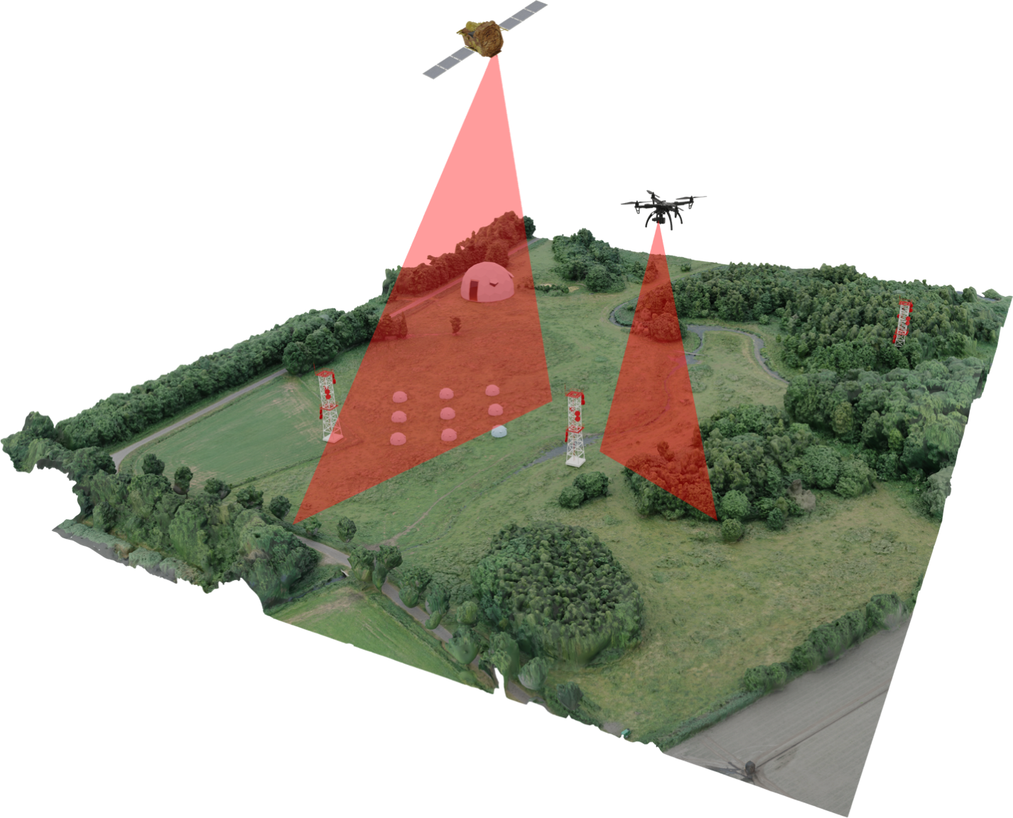
Technologies for measuring the fluxes of air components have been developed for a long time in the framework of fundamental and monitoring meteorological research. To date, measurements by the method of eddy covariances and measurements using soil cameras are recognized as the most accurate and reliable. Such measurements are good for the so-called in situ estimates of fluxes - those that characterize a small area of the landscape. However, when it is necessary to measure the total flux of greenhouse gases of an entire forest or on the scale of some significant territory, remote measuring instruments should be used - scanning multispectral cameras installed on board unmanned aerial vehicles (drones) or satellites. Remote measurements are characterized by reduced accuracy compared to ground-based ones, however, at the same time, satellite measurements cover the territory of Russia almost exhaustively, which potentially makes it possible to estimate the total emission or sequestration of the whole country. To improve the accuracy of greenhouse gas flux estimates using remote sensing, at carbon supesites and collaborating institutions, algorithms based on artificial intelligence methods are being developed to combine the data of ground-based instruments and remote sensing cameras. Such algorithms are built into complex applied systems for assessing the carbon potential of territories.
Separate mention should be made of marine carboniferous polygons, where similar measurements of the fluxes of climatically active gases over the sea surface are carried out. The ocean, depending on the wind, waves, temperature and composition of water, as well as processes in sedimentary deposits, can both absorb and emit greenhouse gases. The instruments used to measure currents on the surface of the ocean are similar to land-based instruments and operate on similar principles. Measurement features associated with sea motion or aggressive measurement conditions in the presence of sea water usually increase the cost of instruments and sometimes change the methodology of measurement experiments, but do not fundamentally interfere with measurements and monitoring.
Measurement and monitoring are, in fact, diagnostic approaches that answer “how much” questions about greenhouse gas fluxes. At the same time, in order to reduce greenhouse gas emissions in the territories or to increase their absorption, it is necessary to answer the questions “why?” To do this, research is being carried out on technologies and approaches to increase the absorption capacity of territories at carbon landfills. In this regard, the list of climatically active gases primarily includes carbon-containing gases: carbon dioxide (CO2) and methane (CH4). The most promising methods of CO 2 absorption today are recognized as carbon accumulation due to the growth of green mass. Different species of trees and shrubs have different ability to accumulate carbon during growth, so the efforts of researchers are focused on identifying species and hybrids that are most active in relation to CO 2. Similar studies are being carried out in marsh landscapes and in the sea with respect to various marine crops and plant communities. characteristic of swamps.
The sciences related to the assessment of the carbon cycle in natural ecosystems have been developing for a long time. The sciences of the meteorological direction are characterized by no less history, within the framework of which methods for accurately measuring the fluxes of gaseous impurities are developed. Due to the increased attention to environmental safety and the problem of a changing climate, these areas of science have attracted special attention of young professionals only recently. The reduced interest on the part of young researchers in the sciences of environmental and meteorological areas compared to the momentarily more promising specialties has led to the fact that there is currently a lack of experts in many areas related to the activities of carbon landfills, environmental safety, and climate risk assessment in general. . As part of the activities of carbon landfill operators, large-scale educational activities are being launched to train young specialists in the areas of environmental management, meteorology, soil science, environmental safety, artificial intelligence and machine learning in the geosciences. To do this, universities that cooperate with carbon landfills or are their operators launch master's programs and special courses. Professional development programs are being launched in similar areas. This allows for the development of a human resources base for the growing carbon landfill project.
Fundamental and applied science is a social phenomenon based on the interaction of experts and their discussions. The development of scientific research is significantly hampered without global cooperation, so the international relations of the carbon polygon teams are the most important area of activity within the framework of the project. International cooperation is aimed at highlighting the results of research by scientific groups of polygons, partner universities and research institutes. In addition, the most important aspect of the activities of the landfills should be the exchange of scientific data - measurement data. Demonstration of research results is one of the main tasks of the research teams of the carbon landfill project . By publishing and discussing such results, the reliability of conclusions about the carbon sequestration potential of Russian territories is increased. As a result, the methods for calculating the export carbon tax on the products of Russian companies may be revised.
Organizing and maintaining a carbon landfill is a complex process. Methodological recommendations of the Expert Council established a list of instruments that are considered the "gold standard" for measuring and monitoring the characteristics of the carbon cycle in natural ecosystems. The purchase of instruments, the organization of measurements, the organization of UAV flights, the organization of field campuses-laboratories for the study of vegetation and soil samples "in the field", the correct and reliable installation of equipment, the setting up of data collection and processing - all this is the responsibility of the carbon landfill operator. Organization of such a complex science-intensive experimental platform requires various competencies of specialists - from organizational, IT and electricians to specialists in the field of machine learning in the geosciences and, of course, experts in fundamental areas: hydrometeorology, soil science, landscape science, geography, ecosystem modeling, geochemistry and others.